
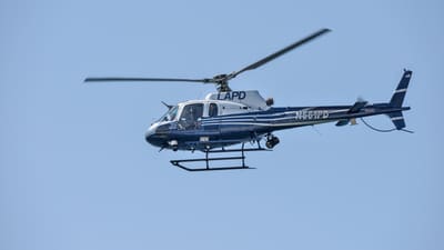

A Los Angeles Police Department helicopter reportedly struck a drone near Tarzana this week, damaging the helicopter's windshield and forcing a precautionary landing at Van Nuys Airport. The FAA and FBI are investigating. The pilot and passenger were not injured, according to reporting from NBC Los Angeles and KABC, and the National Transportation Safety Board was notified but is not investigating because there were no reported injuries or significant damage.
That is the reassuring part.
The uncomfortable part is the altitude and mission context. NBC Los Angeles reports that the LAPD Airbus AS350 was operating near the 101 Freeway and Reseda Boulevard at about 2:52 p.m. Tuesday, assisting officers who were searching for a reported kidnapping suspect. Flight-tracking data cited by NBC placed the helicopter around 1,200 to 1,300 feet at the time of the collision. LAPD described the drone as relatively large, approximately three feet by three feet, and police and the FBI are still looking for the operator.
At this stage, the correct language is still cautious: reported drone collision, FAA/FBI investigation pending, operator not yet identified. But the operator lesson is not pending. It is already written in the numbers.
The 400-Foot Rule Is Not a Suggestion
Under normal Part 107 and recreational rules, small UAS operations are generally constrained to 400 feet above ground level unless a specific exception applies. The Tarzana area described in the reports is within airspace where LAANC-style altitude ceilings matter and where public-safety aircraft can be operating at low altitude with very little warning.
A drone at 1,200 feet is not a minor paperwork problem. It is an airspace integration failure.
For professional operators, this is exactly why UAVHQ keeps coming back to boring fundamentals: pre-flight airspace checks, altitude ceilings, crew briefings, emergency-response awareness, and logs that show what decisions were made before launch. None of that is glamorous. All of it is what separates an aviation operation from a flying camera session.
Emergency Response Aircraft Do Not Have Much Margin
The early reporting initially connected the drone to a nearby Encino brush fire, with LAPD officials suggesting the operator may have been trying to capture aerial footage. NBC later reported that the collision did not occur over the fire itself and that the helicopter had returned to the Tarzana area for a police response. That distinction matters, but it does not save the operator lesson.
Firefighting, law enforcement, medevac, and public-safety helicopters operate dynamically. They may not be in the exact place a drone pilot expects. They may reposition quickly. They may descend, orbit, and work below altitudes most casual pilots associate with crewed aviation. If your operating plan assumes helicopters will stay conveniently away from your shot, it is not a plan.
The professional standard is simpler: if emergency aircraft are operating nearby, land. If the situation is ambiguous, land anyway. The social-media clip is not worth becoming the test case.
Remote ID May Get Another Political Test
If investigators identify the operator quickly, watch how they did it. Remote ID, witness reports, recovered hardware, flight app data, and cell-phone video can all become part of the chain. If there was a compliant Remote ID broadcast near the incident, this may become one of the most visible examples of why the rule exists.
If no Remote ID signal appears and the operator is not found, expect the opposite argument to gain momentum: stronger detection networks, wider counter-UAS deployment, and more pressure on Congress to give local agencies practical authority around airports and public-safety operations.
Either way, the rest of the industry gets pulled into the conversation. One careless operator can become a talking point against everyone from infrastructure inspection teams to DFR programs.
The Operator Checklist
If you are flying commercially, this is the practical response:
- Confirm the ceiling before takeoff. Do not rely on memory. Check the grid, authorization, and mission profile.
- Brief emergency-aircraft triggers. Decide before launch what causes an immediate land-now call.
- Log the decision trail. If an incident occurs nearby, your notes matter. They show whether you were operating as an aviation professional or improvising.
- Treat public-safety traffic as priority traffic. Police and fire aircraft do not owe your drone a predictable orbit.
- Do not chase breaking news with a drone. If the only value of the flight is footage of an active emergency, the risk calculation is already pointing the wrong direction.
This is not anti-drone. It is pro-integration. The only way drones earn more routine access to the airspace is by making the crewed-aviation side believe we can control the obvious risks.
Bottom Line
No one was hurt in Tarzana, and that matters. But a damaged police helicopter windshield at roughly 1,200 feet is exactly the kind of event that hardens regulatory attitudes. It makes Remote ID, counter-UAS detection, enforcement, and Part 108 detect-and-avoid requirements feel less theoretical to the people writing the rules.
The operator takeaway is blunt: altitude discipline is not administrative trivia. Around emergency-response aircraft, it is the difference between a compliant flight and a federal investigation.
Sources: NBC Los Angeles reporting on the Tarzana LAPD helicopter drone collision; KABC-AM report on the FAA/FBI investigation; FAA UAS safety and integration resources; 14 CFR Part 107.
Wesley Alexander is a Former Insitu/Boeing ScanEagle Commercial Chief Test Pilot and former UAS DPE for Insitu ScanEagle pilots and instructors. UAVHQ provides operator-focused intelligence on regulatory and safety developments in the commercial UAV industry.